1.2.3. Medieval cartography
The collapse of the Roman Empire and establishment of new states brought not only political, but also social, religious, and cultural changes. The Byzantine, Latin, Islamic, and also Chinese, Indian, American, and other cultural areas develop to a high degree separately, and the same can also be said about cartography.
In the Latin area - where the leader of education was the Christian Church – a new, biblical concept is created and cartography is more or less limited to illustrating of theological texts. On the other hand, the Arab-speaking world continues in the cartographic tradition of Ancient Greece; however, in the course of time, it is also limited by the influence of Islam. In the Byzantine region, influence of Aristotle’s teaching also prevails. Despite strong opposition from the so-called Syrian School, the concept of globe-shaped Earth is preserved, and continuity with Antic Culture was not disrupted as much as in the Latin area. In China, mapping of borders continues and spreads also to adjacent foreign areas.
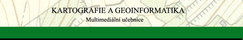
European medieval maps can be divided into three main types: the so-called Mappaemundi (zonal maps, Beatus maps, circular maps); portolan maps and detailed maps of individual regions.
Fig.2.3: Portolan map
